MINAB SCHOOL BOMBING: WHAT EVIDENCE IS THERE THAT THE US WAS RESPONSIBLE? - (Que Bono?)

By Guardian- Tess McClure - Tue 10 Mar 2026 06.00 GMT
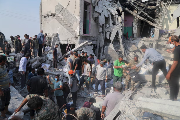
Trump has blamed Iran for the mass killing at Shajareh Tayyebeh primary school but geolocation, videos and satellite imagery indicate otherwise. The bombing of a primary school in Minab on 28 February killed scores of people, most of them seven- to 12-year-old girls.
The strike is the worst mass killing of the US and Israel’s war on Iran so far – and has been described by Unesco as a “grave violation” of international law.
On Saturday, the US president, Donald Trump, declared that Iran was responsible for the school bombing. “In my opinion, based on what I’ve seen, that was done by Iran … they’re very inaccurate, as you know, with their munitions. They have no accuracy whatsoever. It was done by Iran.”
The president presented no evidence for his claim. His assertion has not been repeated by spokespeople for the US military, who have said only that they are “investigating” the bombing.
But a growing body of evidence indicates that the strike on the Shajareh Tayyebeh primary school was carried out by the US. Here is what we know – and why it points to the US being responsible.
Panic as smoke rises after strike on girls’ elementary school in Minab, southern Iran / An aerial view of the school and surrounding areas taken on 4 March with bombed sites marked / A Tomahawk missile hits naval base next to Minab primary school
Where the US was operating during the strikes
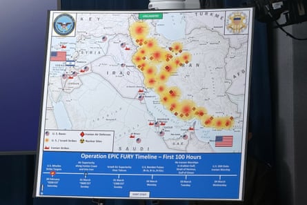
While the US has not explicitly admitted to striking the school or adjacent IRGC barracks, it has said it was conducting strikes in the area. In a briefing at the Pentagon led by Pete Hegseth on 4 March, the US military shared a graphic showing where the US and Israel had conducted strikes during Operation Epic Fury.
While Minab is not labelled on that map, one of the points marked as the location of a US/Israeli strike corresponds to where Minab is located. The graphic also marks where “Iranian strikes” had taken place according to the US military – none are marked in the Minab area.
The map is reinforced by broader US/Israeli intelligence briefings, in which officials have said the US focused its initial strikes along Iran’s southern coastline (where Minab is located), while Israel focused its strikes on the west of the country.
Widely circulated images of a ‘misfire’ debunked
Shortly after the bombing, a number of social media accounts made viral claims similar to those made by the president: that the school had been struck by a misfired Iranian missile. The photographs of the misfire that those accounts present as evidence, however, were taken about 994 miles (1,600km) away from Minab, in the much colder northern city of Zanjan.
The backdrop of the alleged “misfire” photo shows snow-covered mountains, but Minab lies on the far warmer southern coast of Iran; satellite imagery shows no snow-capped mountains in its vicinity. In the foreground of the misfire image, signs for a dentist’s clinic are visible – experts also geolocated that office building to Zanjan. The president has not directly referenced the circulated image, and has provided no further evidence of a misfire.
