LIVE UPDATES: MAJOR NOR'EASTER TO 'BOMB OUT,' CAROLINAS IN THREAT ZONE FOR HEAVY SNOW, INTENSE WIND

Live Updates - Mike Rawlins- Last Update January 29, 2026 at 3:31 PM EST
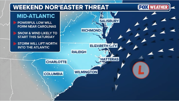
By Fox News-Live updates: Major nor'easter to 'bomb out,' Carolinas in threat zone for heavy snow, intense wind. Live Updates - Live updates: Major nor'easter to 'bomb out,' Carolinas in threat zone for heavy snow, intense wind. A powerful nor'easter is brewing along the East Coast and will take aim on the Carolinas, Virginia, and Mid-Atlantic states as it rapidly intensifies into a bomb cyclone.
A powerful nor'easter will dump heavy snow on millions along the East Coast this weekend.
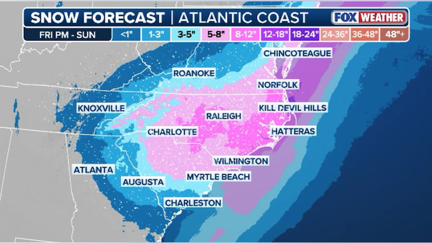
Coastal storm to clobber the Carolinas in nearly a foot of snow
Just days after a historic winter storm swept the nation, a new storm threatens to bury parts of the East Coast in nearly a foot of snow. The FOX Forecast Center says a powerful low pressure area will form just off the coast of the Carolinas by Saturday, spinning into a dangerous nor'easter as it tracks north along the coast. This coastal storm will drop heavy snow over the Carolinas, Virginia, and coastal sections of the Mid-Atlantic states on its journey north across the Atlantic. And the snow won't be the only threat. Dangerously strong winds are expected to lash the coast, kicking up huge waves, triggering coastal flooding, and eroding vulnerable beaches.
Posted by Mike Rawlins Share4 min(s) ago
Nor'easter prompts major U.S. airlines to issue travel waivers
This weekend's nor'easter will likely trigger more travel headaches along the East Coast. Major U.S. airlines are preparing for delayed and canceled flights by issuing travel waivers ahead of the storm. Those waivers often allow passengers to reschedule and rebook their flight without paying a change fee.
Here are the travel waivers issued so far:
Posted by Mike Rawlins Share11 min(s) ago
I-95 corridor to miss out on this weekend's big snow
While people work to clear away the snow from last weekend's historic winter storm, the last thing they want to hear is that another storm is on the way. Fortunately for the millions that live along the I-95 corridor in the Northeast, this new storm will largely miss the region.
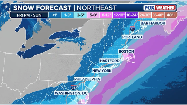
Latest snow forecast from FOX Weather showing most big cities missing out on this weekend's snow.
Snow is expected in New York down to Philadelphia and into Washington on Sunday, but these cities will likely see less than an inch of accumulation. The heaviest snow will fall in southeast Massachusetts on Cape Cod. The FOX Forecast Center says the cape could see up to a foot of snow with dangerously strong winds up to 70 mph. It's this area that may experience blizzard conditions on Sunday as the powerful nor'easter bombs out over the Atlantic.
Posted by Mike Rawlins ShareBreaking News17 min(s) ago
NEW snow forecast from the FOX Forecast Center
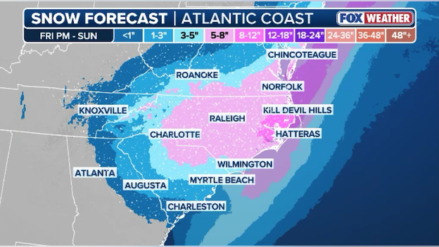
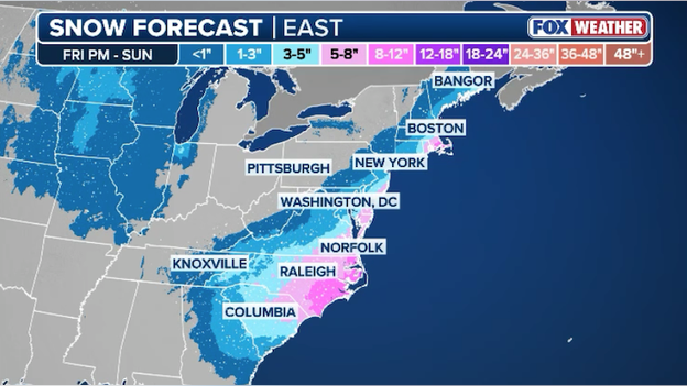
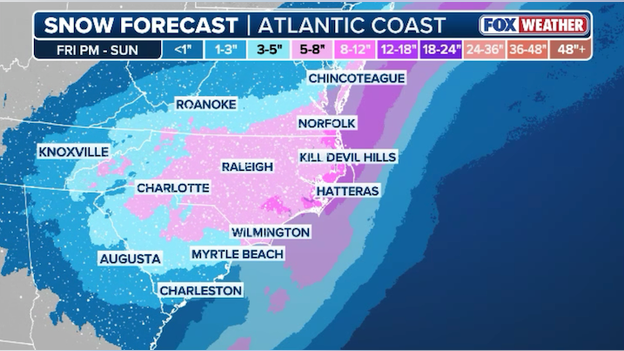
Latest snow snow from FOX Weather showing heavy snow this weekend for the Carolinas.
The FOX Forecast Center just released an updated snow forecast for this weekend's nor'easter. Heavy snow is expected to fall across most of North Carolina, northern South Carolina, and southern Virginia starting on Friday and winding down early Sunday. The heaviest snow is expected right along the coastline where as much 8-12 inches of snow could fall.
Posted by Mike Rawlins ShareBreaking News40 min(s) ago
North Carolina Governor declares State of Emergency ahead of nor'easter
North Carolina Governor Josh Stein has issued a new State of Emergency to ensure his state qualifies if federal assistance is needed to respond or recover from the weekend nor'easter. The declaration also activates the State Emergency Response Team ahead of the storm’s arrival.
Our emergency management teams and NCDOT crews continue to work around the clock, and I’m grateful for their continued dedication to keeping North Carolinians safe.- North Carolina Governor Josh Stein
The state's transportation secretary says crews have completed clearing most of the snow and slush from last weekend's storm and they're already pretreating roads ahead of this upcoming weekend's storm.
Click here to read the press release.
Posted by Mike Rawlins Share44 min(s) ago
SCDOT crews pretreating roads before the first flake flies
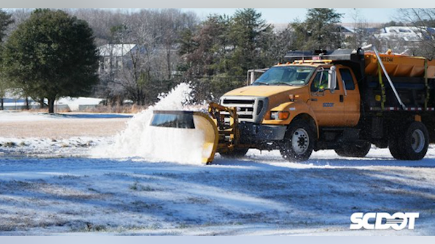
South Carolina Department of Transportation plow pushing snow.
The South Carolina Department of Transportation says it is coordinating with emergency management partners ahead of this weekend's nor'easter. Right now, crews are out pretreating roads before the first flake even falls. SCDOT is also preparing crews and equipment to clear the roads when the storm ramps up.
Posted by Mike Rawlins ShareBreaking News51 min(s) ago
State of Emergency declared in Kinston, North Carolina ahead of nor'easter
The city of Kinston, North Carolina is not taking any chances with the threat of heavy snow and dangerous winds this weekend. The city has declared a State of Emergency ahead of the storm. It is also imposing a curfew for people starting at 5 p.m. ET on Saturday and ending 8 a.m. ET on Sunday.
Click here to read the declaration.
Posted by Mike Rawlins Share54 min(s) ago
Florida facing dangerously cold wind chills this weekend
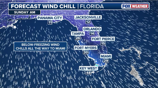
Wind chill temperatures are expected to reach the 10s and 20s in Florida on Sunday morning.
The Sunshine State is gearing up for what could be some of the coldest weather in 15 years. By Sunday morning, actual air temperatures are forecast to reach the 20s across Central Florida. Even Miami won't escape the cold. Sunday morning's low temperature is expected to dip down to 36°F.
But the temperature is only half the story. Powerful northwest winds will be pushing that frigid air farther and farther south. Gusts of 30-40 mph will be common across the state. And that will have a dramatic impact on the wind chill temperature.
Wind chills are predicted to plunge into the 10s and 20s all the way down to Miami. These bone-chilling numbers aren't just cold, they're dangerous. With wind chills this low, frostbite can set in within an hour. That means everyone should be bundling up, covering exposed skin and avoiding prolonged periods outdoors in these extreme conditions.
Posted by Mike Rawlins Share1 hour(s) ago
North Carolina Emergency Management: winterize your home now
Posted by Mike Rawlins Share1 hour(s) ago
Hurricane Hunters en route to gather data for developing nor'easter

NOAA Gulfstream IV jet flies over storms and gathers data on the state of the atmosphere.
NOAA's Hurricane Hunters are en route to gather vital data ahead of the developing nor'easter, data that will help improve computer forecast models. A NOAA Gulfstream IV just took off from its base in Lakeland, Florida. It will fly ahead of where the storm is expected to develop in order to get a better idea of how the atmosphere is shaping up. The data it collects will be fed directly into the powerful supercomputers that produce weather forecast models, which has been been proven to increase forecast accuracy.
Posted by Mike Rawlins Share2 hour(s) ago
North Carolina bracing for the most snow in nearly 70 years
Latest snow forecast from FOX Weather showing heavy snow hammering North Carolina this weekend.
The FOX Forecast Center is calling for nearly a foot of snow to fall on parts of North Carolina this weekend. FOX Weather's latest snow forecast shows parts of the Piedmont and North Carolina's Sandhill region getting 8-12 inches as a nor'easter rapidly intensifies off the East Coast. Data from the North Carolina Climate Office reveals some of these areas haven't seen this much snow in 68 years.
Posted by Mike Rawlins ShareBreaking News2 hour(s) ago
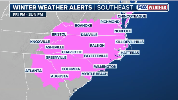
First Winter Storm Warnings issued ahead of nasty weekend nor'easter
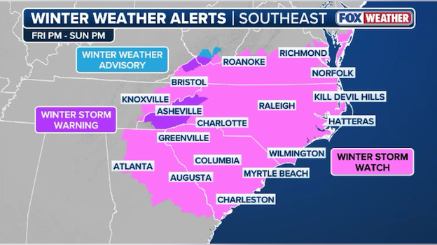
Winter Storm Warnings have been issued for western North Carolina, western Virginia, and eastern Tennessee.
With less than 24 hours before the first flakes fly, the National Weather Service has begun issuing Winter Storm Warnings for western North Carolina, western Virginia, and eastern Tennessee. This includes Asheville, North Carolina.
The FOX Forecast Center says this area could see 5-8 inches of snow with winds gusting up to 55 mph. This combination could make many roads impassable and may lead to power outages due to the weight of the snow on tree limbs and power lines.
Posted by Mike Rawlins Share3 hour(s) ago
Charleston, South Carolina now under a Winter Storm Watch
The National Weather Service just issued a Winter Storm Watch for Charleston, South Carolina ahead of this weekend's nor'easter. The watch says heavy snow could driving very difficult from Saturday morning through Sunday afternoon. Right now, the FOX Forecast Center says 1-3" of snow is likely in and around the Charleston area.
Posted by Mike Rawlins Share3 hour(s) ago
Winter Storm Watch issued for Atlanta as snow threat increases
Winter Storm Watches are in effect from North Georgia to Delaware.
The National Weather Service in Atlanta just issued a Winter Storm Watch for the Atlanta metro area ahead of this weekend's nor'easter. The watch is up for Friday evening through Sunday morning and says snow accumulations could reach up to 2 inches with winds gusting to 35 mph. Drivers should plan for hazardous driving conditions, especially on bridges and overpasses.
Posted by Mike Rawlins Share3 hour(s) ago
FOX 13 Tampa meteorologist Paul Dellegatto weighs in on Florida flurry potential
Posted by Mike Rawlins Share3 hour(s) ago
Georgia Governor says state is preparing for weekend storm's impacts
We’re not taking our eye off the ball when it comes to winter weather.- Georgia Governor Brian Kemp
In a post on X, Georgia Governor Brian Kemp says "While response to last week’s storm may be winding down, we’re already monitoring and preparing for what this weekend could bring. Forecasts suggest this system will be very different and smaller in impact, but I’m still urging Georgians to remain weather aware and stay tuned for updates."
Posted by Mike Rawlins Share3 hour(s) ago
South Carolina Emergency Management: take steps now to prepare
The South Carolina Emergency Management Division is actively monitoring a weather system that is expected to bring snow across the state Friday night into Sunday morning.
SCEMD officials are coordinating with the State Emergency Response Team, the National Weather Service and local emergency managers to track the system and share timely updates and guidance on potential impacts across South Carolina.
Posted by Mike Rawlins Share4 hour(s) ago
50 miles east or west mean make-or-break snow for New York, Philadelphia
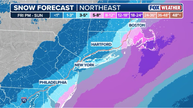
FOX Weather snow forecast for the heavily-populated I-95 corridor of the Northeast.
The FOX Forecast Center says this weekend's nor'easter will largely miss big cities like New York and Philadelphia. But a change in the storm's track - just 50 miles east or west - could mean the difference between no snow and big snow.
FOX Weather's latest snow forecast for the Northeast shows just how close New York and Philadelphia will be to those big snow totals. Right now, the heaviest snow is expected to fall right along the South Jersey coastline and up toward southeast Massachusetts and Cape Cod. It's these areas that could pick up nearly a half foot of snow through Sunday. Farther west, only an inch or two is expected to fall along I-95.
Forecasters warn that should the storm change its path, shifting west or east, could result in a change in these snow totals. Meteorologists at FOX Weather are closely monitoring incoming computer model data to provide the most accurate forecast for this weekend's storm around the clock.
Posted by Mike Rawlins Share6 hour(s) ago
High Wind Watch issued for Outer Banks of North Carolina
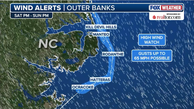
High Wind Watch issued for portions of North Carolina this weekend.
Dangerously strong winds are expected to blast the North Carolina coastline this weekend. The National Weather Service in Newport/Morehead City has issued a High Wind Watch for the Outer Banks of North Carolina. This includes Hatteras Island, the Northern Outer Banks, and Ocracoke Island. The watch is for 40-50 mph winds with gusts up to 65 mph starting Saturday evening into Sunday. These damaging winds could blow down trees and power lines. The watch warns widespread power outages are possible and travel could be difficult, especially for high profile vehicles.
Posted by Mike Rawlins Share6 hour(s) ago
Satellite reveals huge extent of historic winter storm
Posted by Mike Rawlins Share6 hour(s) ago
Meteorologists Britta Merwin & Craig Herrera break down this weekend's nor'easter
Posted by Mike Rawlins Share6 hour(s) ago
Power outages drop below 100,000 in Mississippi for first time since Sunday
Posted by Mike Rawlins Share7 hour(s) ago
NWS says Outer Banks blizzard possible this weekend in North Carolina
Posted by Mike Rawlins Share7 hour(s) ago
Florida flurries expected as rare Gulf-effect snow ramps up
Yes, you read that headline correctly. Florida could see flurries this weekend due to a rare setup that will trigger "Gulf-effect snow." Areas from the Big Bend of Florida down to the Fort Myers/Naples region could see snowflakes.
Unusually cold air is forecast to sweep across the South and into Florida this weekend - some of the coldest the Sunshine State has felt in over 15 years. On Saturday night, lingering moisture from the nor'easter barreling up the East Coast could mix with the dangerously cold air and produce flurries or a rain/snow mix along Florida’s Gulf Coast.
This is similar to lake-effect snow, which you often hear about happening in the Great Lakes. Lake-effect snow forms when very cold Arctic air moves over warmer water. The air just above the water warms slightly, rises quickly through the colder air above, forming clouds and producing snow downwind.
In Florida, “Gulf-effect snow” can happen when frigid air rolls over the relatively warmer Gulf waters. For this to happen, there needs to be a long fetch of northwest winds picking up moisture, combined with a big enough difference between the water temperature and the cold air above. The larger the temperature difference, the faster the air rises boosting the chance of snow formation.
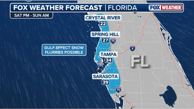
Gulf-effect snow could bring flurries to Florida's Gulf Coast from the Big Bend down to Sarasota, FL.
The FOX Forecast Centers says the chance for a rain/snow mix Saturday night is low, with only flurries possible along coastal areas. To put this in perspective, measurable snow in Florida is incredibly rare. Tampa has only recorded measurable snow twice: 0.2" on January 19, 1977, and 0.1" on February 13, 1899. Naples, FL, which could also see flurries, has never recorded measurable snow. While flurries have been observed in Central Florida before, accumulating snow is exceptionally difficult due to warm ground temperatures.
Posted by Mike Rawlins Share7 hour(s) ago
Nor'easter to become a 'bomb cyclone' over the Atlantic
FOX Weather meteorologists say this weekend's nor'easter will undergo rapid intensification, a process known as "bombogenesis." It's often referred to in flashy headlines as a "bomb cyclone" or you may hear experts say it's going to "bomb out."
But what exactly does that mean? FOX Weather explains the terminology and how it happens.
Posted by Mike Rawlins Share7 hour(s) ago
Snow starts flying in less than 36 hours
Exclusive FOX Weather Model shows snow developing across North Carolina and Virginia on Friday.
Time is running out to prepare for this weekend's nor'easter. The exclusive FOX Weather Model shows snow starting to develop across North Carolina and Virginia as early as Friday afternoon, becoming widespread by dawn on Saturday.
Posted by Mike Rawlins Share7 hour(s) ago
Dangerous winds to whip the East Coast as nor'easter rapidly intensifies
While the snow will make headlines this weekend, some of the most serious impacts will come from the wind. There is growing concern that the combination of 60–70 mph onshore wind gusts, high surf, and significant beach erosion could lead to scenes reminiscent of impacts seen during the recent hurricane season, including the potential loss of additional homes.
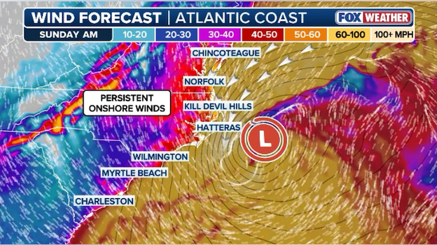
Powerful onshore winds could lead to coastal flooding, beach erosion, and tree damage near the coast.
Unlike the storms from the 2025 hurricane season, this system is expected to track very close to the coastline, allowing for near hurricane-force gusts in some coastal locations. Snow is also likely to reach areas such as Wilmington, North Carolina, Myrtle Beach, South Carolina, Charleston, and the Outer Banks of North Carolina. If the timing of the heaviest snow overlaps with the strongest winds, ground blizzard conditions could even develop, especially along the North Carolina coast.
Posted by Mike Rawlins Share8 hour(s) ago
75 million Americans at risk for snow this weekend
Latest snow forecast from FOX Weather showing the path of this weekend's nor'easter.
FOX Weather's snow forecast has 75 million Americans in the path of this weekend's nor'easter. Snow is expected to start flying over the Appalachians on Friday and spread across the Carolinas by Saturday morning. Unlike last weekend's historic winter storm, this one will be a coastal storm, directing its fury toward coastal areas from Georgia to Maine. At this time, the heaviest snow is expected to fall on eastern North Carolina and Virginia. As the storm moves north, it's also predicted to drop heavy snow on Cape Cod in Massachusetts.
Posted by Mike Rawlins Share8 hour(s) ago
Coast Guard cutter frees NYPD vessel from icebound Hudson River
Posted by Mike Rawlins Share9 hour(s) ago
Analysis: why New York and Boston will miss out on blockbuster snow this weekend
Millions of Americans are still digging out from last weekend's historic winter storm, so the prospect of another has many on alert. Fortunately for big cities like New York, Philadelphia, Washington, and Boston, this weekend's nor'easter will largely miss them.
Any meteorologist will tell you that the East Coast's biggest snowstorms come in the form of an old-fashioned nor'easter. Low pressure develops off the East Coast and charges north, spreading heavy snow to areas along the coast. This is how the heavily-populated Interstate 95 corridor gets its big snows.
So why won't this weekend's storm deliver blockbuster totals? Forecasters use something called the "benchmark" to help them determine whether or not the Northeast and Mid-Atlantic will get walloped by heavy snow. The benchmark is the so-called "40/70 benchmark," located at 40 degrees north latitude and 70 degrees west longitude. For reference, that's some 80 miles south of Massachusetts' Nantucket Island.
If cold air is sufficient over the Northeast, a low-pressure system tracking over this sweet spot has the potential to be a blockbuster snowstorm for parts of the region. Many of the major winter storms that impact Boston, New York City, Philadelphia and Washington pass very close to the 40/70 benchmark during their journey northward off the East Coast. The famed "Blizzard of '96" was one such example that brought heavy snow to all those major cities.
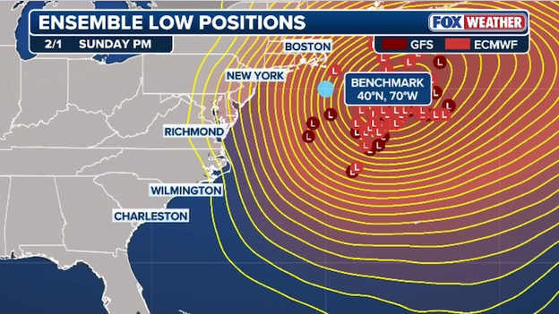
Computer forecast models show this weekend's winter storm tracking farther east off the U.S. East Coast.
A difference of 50 miles to the left or right of that point can have a huge implication on the forecast, and that's why uncertainty can be high even a day or two before the winter storm's arrival. The FOX Forecast Center says computer forecast models have consistently indicated this upcoming weekend's center of pressure will stay east of the benchmark, which means little to snow along I-95. That's certainly welcome news to the thousands of workers still clearing streets of snow and ice across the region.
Light snow (possibly an inch) is still expected from near Boston to New York to Washington, but the storm's worst impacts will be seen and felt across the Carolinas where the low will initially form closer to the coast.
Posted by Mike Rawlins Share10 hour(s) ago
Utility crews working tirelessly to restore power to hard-hit South
Thousands are still without power across the South following last weekend's historic winter storm. Crippling ice coated portions of Louisiana, Mississippi, and Tennessee, downing trees and power lines and paralyzing the region. Restoration efforts have been hampered by the ongoing extreme cold and icy conditions throughout the region.
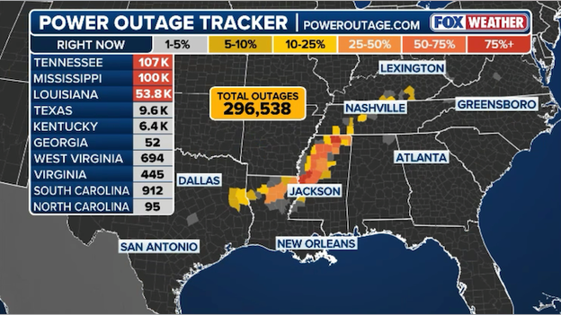
Latest power outage tracker showing county-by-county outages in the Deep South. (PowerOutage.com)
Hundreds of lineman and crews from across the South have answered the call to help get the lights back on in the most hard-hit areas. Data from PowerOutage.com shows remarkable improvement in the past 24 hours, but nearly 300,000 customers still don't have electricity this morning. Crews are working around the clock to help repair damaged power poles and transmission lines in multiple states.
Posted by Mike Rawlins Share10 hour(s) ago
WPC warns significant snowstorm threat increasing for the Carolinas
Posted by Mike Rawlins Share10 hour(s) ago
Hour-by-hour timing of this weekend's nor'easter
Posted by Mike Rawlins Share10 hour(s) ago
Heavy snow to hammer the Carolinas this weekend
Latest snow forecast from FOX Weather showing more than a half foot of snow predicted to fall across the Carolinas.
The FOX Forecast Center says a dangerous nor'easter will slam the Carolinas and Mid-Atlantic with heavy snow starting as early as Friday. Significant snow is predicted to fall along the Piedmont to the coast, and could disrupt travel across the region. Charlotte, North Carolina and Raleigh, North Carolina are expected to see 5-8 inches of snow from this potent storm, while the Outer Banks of North Carolina could get nearly a foot of snow.
Norfolk, Virginia and the Virginia Beach area could also be looking at more than a half foot of snow this weekend. Farther south, light snow is expected across North Georgia and as far south as Charleston, South Carolina.
Posted by Mike Rawlins Share10 hour(s) ago
Winter Storm Watches issued across 6 states
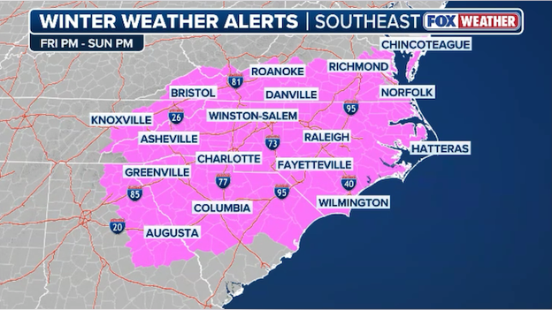
Winter Storm Watches are now in effect for six states ahead of this weekend's major nor'easter.
The first weather winter alerts for the upcoming nor'easter were just issued by the National Weather Service. Winter Storm Watches now cover most of North and South Carolina, southern Virginia, part of Delaware, eastern Tennessee, and parts of North Georgia. The watches go into effect on Friday and end Sunday. NWS warns strong winds and the weight of snow on trees may down power lines and could cause power outages. Travel may become dangerous or even impossible with widespread closures and disruptions to infrastructure possible.
Read more on what a Winter Storm Watch is and means for you.
Posted by Mike Rawlins Share10 hour(s) ago.
GEOENGINEERING OVER OUR HEADS-WEF DAVOS CONFIRMS.By Arnt Remy Åvik-Langstrand-Human Synthesis-26 January 2026.